Parking permit area maps
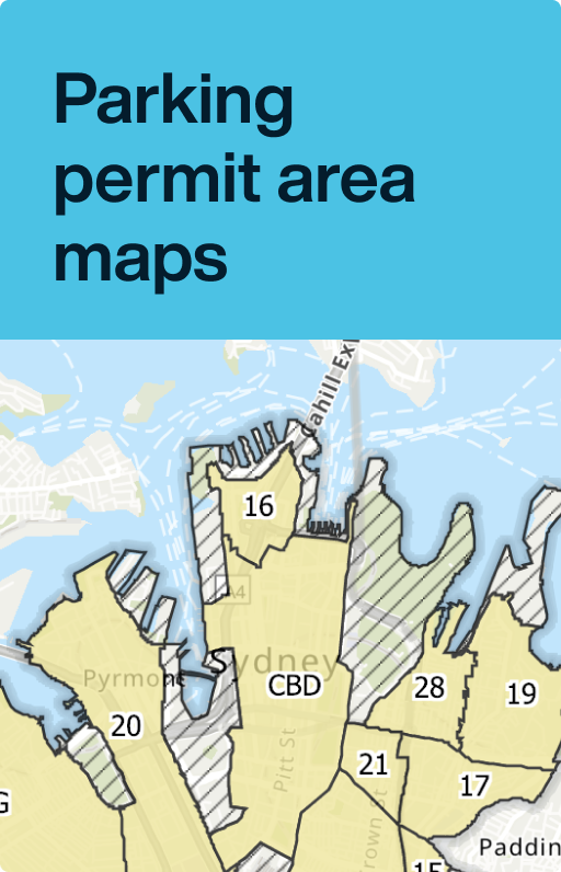
The City of Sydney's local area is divided into 16 parking areas. Permits are valid only in the area where you live or operate a business.

Find your parking area
Click on the map below to find out about parking in your area including the number and type of permits available.
Parking areas by suburb or general location
The CBD parking area is bordered by Alfred Street, Macquarie Street, College Street, Wentworth Ave, Elizabeth Street, Eddy Ave, Pitt Street, Railway Square, Haymarket, Harbour Street, Sussex Street, Lime Street, Hickson Road, Gloucester Street, Essex Street and George Street.
The Glebe parking area incorporates the suburbs of Glebe and Forest Lodge, and the area of Camperdown north of Parramatta Road, bordered by Mallett Street, Booth Street and Wigram Road.
Area 13 is bordered by Oxford Street, Lang Road, Martin Road, Anzac Parade, Robertson Road, Cook Road, Furber Lane, Poate Road, Moore Park Road and Oatley Road.
Map: Area 13 South Paddington & Centennial Park (PDF, 48.57KB)
Area 15 is bordered by Oxford Street, Greens Road, Moore Park Road and Flinders Street.
Area 16 is bordered by Dalgety Road, Windmill Street, Downshire Street, Fort Street, George Street, Essex Street, Gloucester Street, Cumberland Street, Kent Street, High Street and Merriman Street.
Area 17 is bordered by William Street, Craigend Street, Neild Avenue, Boundary Street, Barcom Avenue, Oxford Street, Bourke Street, Stanley Street and Palmer Street.
Area 18 is bordered by Oxford Street, Flinders Street, South Dowling Street, Cleveland St, Chalmers Street, Elizabeth Street and Wentworth Ave.
Area 19 is bordered by Cowper Wharf Roadway, the ADI Naval Dockyard, Elizabeth Bay, Rushcutters Bay Park, Neild Avenue, Craigend Street and Victoria Street (between William Street and the McElhone Stairs).
Area 20 is bordered by Johnstons Bay, Pirrama Road, Murray Street, Pyrmont Street, Harris Street, Broadway, Bay Street, William Henry Street, Wattle Street and Blackwattle Bay.
Area 21 is bordered by William Street, Palmer Street, Stanley Street, Bourke Street, Oxford Street and College Street.
Area 22 is bordered by Parramatta Road, Missenden Road, Carillon Avenue, Golden Grove Street, Wilson Street, Iverys Lane, Leamington Lane, Copeland Ave, Railway line, King Street, Church Street, Salisbury Road and Mallet Street.
Area 28 is bordered by Cowper Wharf Roadway, Brougham Street, William Street, Yurong Parkway, Sir John Young Crescent, Lincoln Crescent and the Woolloomooloo Finger Wharf.
Area 32 is bordered by Broadway, Lee Street, Regent Street, the western side of the Railway Reserve, Little Eveleigh Street, Wilson Street, Golden Grove Street, Darlington Road, Codrington Street, Abercrombie Street, Raglan Street, Lander Street, Shepherd Street, Cleveland Street and City Road.
Area 35 is bordered by Sydney Park Road, Euston Road, McEv cvoy Street, Botany Road, Bourke Street, O'Dea Ave, South Dowling Street, Southern Cross Drive, Gardeners Road, Canal Road to the western boundary of the St Peters Waste Transfer Station, Barwon Park Road and King Street.
Map: Area 35 Zetland, Beaconsfield & Rosebery (PDF, 235.04KB)
Area 36 is bordered by the southern boundary of the Railway Reserve, Explorer Street, Rowley Street, Henderson Road, Botany Road, McEvoy Street, Euston Road, Sydney Park Road and King Street.
Area 41 is bordered by Cleveland Street, South Dowling Street, O'Dea Ave, Bourke Street, Botany Road, Henderson Road, Garden Street, Cornwallis Street, Marian Street, Gibbons Street and Regent Street.


